riverssa

WW kayaking guide to rivers in South Africa


Leave a comment

WIldebees Gorge / Wildebees River / Transkei / South Africa

Wildebees River – Wildebees Gorge

WIldebees (Nqu) Section : Wildebees River

Grading IV-  at low levelsIV at medium levels (two foot from wider column support at put-in bridge)

IV+ (V) if the water is humping.

Levels / gauges None.  Check rainfall in area.  Best bet is to go Mid January to February.  Check with Tsitsa falls backpackers for river level updates.Note: Marker at bridge is the columns.  If the fat bottom section of the column is just covered, then this is the minimum level
Put-in 31°11’54.58″S ; 28°25’53.73″ETurn off from R 396:

31° 8’21.47″S ; 28°26’14.99″E

Take-out 31°15’50.26″S ; 28°29’16.77″E
Estimated time 4hr to 7hrs
Length 16km
Gradient Proper gorge to second falls: 22m/km  (8km)Average: 15m/km (over total length)
Portages None
Hazards / Notes Logs / siphons / waterfalls
Fun factor 4 / 5

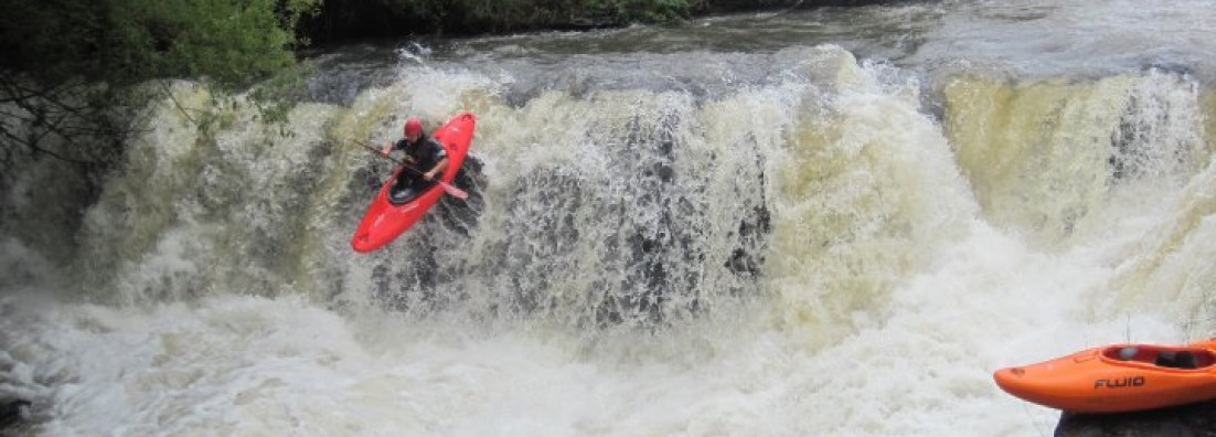
Wildebees section is best known for the two waterfalls on this section.  The first one is about 15m high and the second around 10m.  Both is good to go, but beware that the 15m packs a punch in terms of hitting the plunge pool.  Even if you are not keen on the waterfalls, the section has some solid rapids and the scenery is awesome.  The higher the water level, the more committing the run becomes.

The road to the put-in is off the R396 heading south of Maclear.  The turn-off will be on your right heading south and at 31° 8’21.47″S ; 28°26’14.99″E.  There is a precast bus shelter at the turn-off and a white sign with “Mbidlana JSS” on it.  Carry on with the dirt road until you cross the river.  You can check the levels at the put-in bridge:

Low level: Water covers just about the fat section of the bridge column.

Medium level: Say about two feet up from the fat section.

High level: Anything more than 3 feet up and you will see that the water is brown.

The take-out is a bit of a dirt road mission.  Carry on with the R396 to a turn-off at 31°14’50.80″S ; 28°38’21.31″E.   The turn-off is not clearly marked, but is a proper dirt road into the rural areas. It is roughly 32km from the Wildebees put-in turn-off and about 3km after you cross a medium sized bridge (see pic below of bridge and actually the lower Wildebees).

Image

From the turn-off of the R 396, carry on with the dirt road and try and stick to the larger roads going right and towards the river.  The take-out is roughly 18km down this road where the road comes close to the river and just before a steep road heading out of the valley.  If you go up this steep road, you will be able to see the second falls to your right.  Take-out is at  31°15’50.26″S ; 28°29’16.77″E.  From the river, you will be about 2.5 km downstream of the second waterfall and will be able to see the steep road running out the valley (From the second falls the river makes a 90degree turn to the left and you will be able to see the road leading out of the valley over your right shoulder).

The river itself starts out pretty mellow.  The first couple of kilometers have a bit of wood, but nothing too serious.  It seems that most of it is kept out of the main gorge, but always be on the look-out for logs.

The first mini-gorge is just around the corner from the put-in.  The proper gorge and steeper sections is about 5km from the put-in.  From here you need to be on your game and scout when in doubt.  There are undercuts and siphons a plenty.  Hiking out becomes difficult and the runs is pretty committing.

The first falls is the 15m falls and can be run on the left.  Portage is on the right and can be a bit dodgy due to the narrow path so take it slow.  The waterfall has a pretty hard hit at the bottom.  The waterfall is remote, but the lead-in is as easy as it gets.  If you are new to waterfalls, rather give this a miss since the consequences on this one can be high.  The drop is rewarding to the okes up for it.  The waterfall is about 7km into the run.

The section between the waterfalls is more of the same.  The second fall is 13km into the run and almost at the end.  The entry is easy and the line depends on the water levels, but there are numerous lines down.  After the second fall, carry on down to the take-out.

Note that the proper gorge is fairly steep at times and you need to be confident at high water levels.  Rapids are too numerous to describe, however there is a line down each of them.  Again, watch out for siphons, undercuts and the odd log.  The Wildebees is a great run and definitely one of the classic Transkei paddles.

ImageImageImage


Leave a comment

Pot Gorge / Pot River / Transkei / South Africa

Pot River – Pot to Tsitsa

Pot to Tsitsa Section : Pot River

Grading  IV-  (IV+)
Levels / gauges None.  Check rainfall in area.  Best bet is to go Mid January to February.  Check with Tsitsa falls backpackers for river level updates.

Note: The water level might be low at the put-in, but there is a confluence

Put-in 31° 1’29.31″S ; 28°25’33.80″E
Take-out Option 1 (Short): 31° 2’22.60″S ; 28°29’18.71″E

Option 2 (Long): 31° 6’21.37″S ; 28°30’53.39″E

Estimated time 3hr to 5hrs (Short)

5hrs to 7hrs (Long)

Length 10km (Confluence take-out)

15km (Long)

Gradient 18m/km (Pot)

10m/km (from Tsitsa down)

Portages None
Hazards / Notes Logs / siphons
Fun factor 4 / 5

The Pot is a little bit milder than the Tsitsa upper gorge, but deserve some respect since it is still pretty continuous in places and hazards like logs, siphons and undercuts are strewn throughout the section.  The good news is that all rapids are good to go and fairly to scout either from the side or from your boat.  Remember that when in doubt scout.  If you can’t see the bottom of the rapid then get out on scout.  The section is again in a gorge with steep side walls.

Put-in:  The put-in is easy to get to.  You can either put-in at the bridge crossing the river or a little downstream after the first rapid (the first rapid is normally full of logs).  To get there:  When leaving Tsitsa Falls backpackers, take the first left and carry-on until you cross the Pot River.  Leaving from Maclear, take the first Tsitsa Falls turn-off from the R56.

There are several rapids on this section and some of them may need some scouting.  Be aware that there are a lot of trees/logs in the river for the first half of the section (say until the confluence with the Mooi River).  After the confluence with the Mooi there is a weir across the river which you can scout from either river left or right.  The weir is runable; make check your line and the rapid after.

Image

Rapid below weir.

Image

Slide on Pot.

It is really difficult to describe any of the rapids on this section.  It has similar characteristics than the Tsitsa Upper Gorge.  If you liked the Tsitsa, you will like the Pot.  Again the scenery is awesome and the rapids are pretty sweet.  The Pot gets better with higher levels.

Take-out: Take-out is either at the confluence of the Tsitsa River or you can paddle past the confluence and use the take-out for the long section of the Tsitsa Upper Gorge (See Tsitsa Upper Gorge entry).  When taking out at the confluence, aim for the gully on river left for the take-out.  The hike-out is pretty intense and you need to cross two fences before you are at the top.  To drive to the take-out chat to AD at http://www.tsitsafalls.com.  As you leave the backpackers you will cross a wetland with a dam on your left.  Take the farm road just after crossing the wetland on your left and carry-on towards the sheds.  At the sheds keep right.  From here the track starts to deteriorate and you will have to check where it runs.  Drive towards the fields and keep right until you come to the edge of the gorge and you can see the Pot River below. This is private land so check with the Tsitsa Falls backpackers and close all the gates.


Leave a comment

Tsitsa Upper Gorge / Tsitsa River / Transkei / South Africa

    Tsitsa River – Tsitsa Upper Gorge

Tsitsa Upper Gorge : Tsitsa River

Grading  IV- to IV+ (V when high)
Levels / gauges None.  Check rainfall in area.  Best bet is to go Mid January to February.  Check with Tsitsa falls backpackers for river level updates.

Low – water is greyish and you can see bump&scrape lines.

Medium – Most of the rocks are covered on the lines.  Water is brownish.

High – Water is brown and pushy

Put-in 31° 1’9.39″S ; 28°28’56.35″E
Take-out Option 1 (Short): 31° 1’22.78″S ; 28°29’32.58″E

Option 2 (I like to hike):

31° 2’22.60″S ; 28°29’18.71″E

Option 3 (Long): 31° 6’21.37″S ; 28°30’53.39″E

Estimated time 1hr to 3hrs (Short)

3hrs to 6hrs (Long)

Length 2km (Short)

5km (Pot take-out)

15km (Long)

Gradient 25m/km (Short)

20m/km (Pot take-out)

10m/km (from Pot down)

Portages Waterfall at start
Hazards / Notes Logs / siphons
Fun factor 4 / 5

Looking to warm-up for some Transkei action?  Then the Tsitsa Upper Gorge is perfect.   It is continuous, tricky and can dish out a beating.  The best part is that it is on the doorstep of the best base camp for paddling in the Transkei – Tsitsa Falls backpackers (http://www.tsitsafalls.com).  Check with them for up to date water levels.

The put-in is a short walk from the backpackers.  Get-in at the bridge above the falls and paddle down to just above the falls and portage on the left, or get in at the falls (you can drive to the falls on either the left or right side of the river with the right side having a dedicated road).

The first two rapids need to be scouted for all levels.  The first one has a nice siphon in the middle of the rapid.  The line is to take a sneak on river right and then cut-back left through a slot to the main flow (Siphon will be on your left).  Best to scout on your way down while portaging the waterfall.

Image

                       First rapid with line being right to left.  Siphon in middle of picture.

The second rapid is best to scout from river left.  The problem with the second rapid is that the main line is on river right, but there is almost always something stuck in the last slot (logs).  The line is to enter either river right and finish with a boof on river left, or to start left and end left with the boof.

Image

Second rapid boof on river left

The action doesn’t let up from here and you need to be on your toes.  If you haven’t paddled this section before or one of the guys in the crew, best is to walk the rim of the gorge and scout the rapids from the top.  Scout on the left rim of the gorge.  Chat to AD (http://www.tsitsafalls.com) before you get onto the river.  Be aware of logs on the river. Once you get to a slide rapid (really fun at high water) be sharp for the following rapid with large boulders and then the one after this (second rapid after the slide) has a massive syphon on river left (keep right).  Check out Luke’s trip report at http://adrian.playak.com/index.php/sa-other-provinces-mainmenu-17/221-tsitsa-gorge-finally.

If you are a capable boater in class IV+ and up you will be able to boat scout the remainder of the rapids.  The river is steep and continuous and can be rewarding for the competent and confident paddler.

The upper gorge is short and a lot of fun.  You have three take-out options:  Option 1 is to continue until you get to a river wide hole with a double step.  Take-out after this on the left and carry your boat up to the top by cutting back slight upstream. (31° 1’22.78″S ; 28°29’32.58″E)

Option 2 might not be the best since the hike-out is hectic.  Paddle down to the confluence with the Pot River and take-out.  Take-out at the confluence of the Pot River on the right (river left of the Pot River).  Walk a bit upstream until you see the gully and walk to the top (pass two fences and then cut back to the left to the top – see details under the Pot River). (31° 2’22.60″S ; 28°29’18.71″E)

Option 3: Carry-on past the Pot River confluence until the gorge opens.  You will get to a village and this is the take-out.  The rapids in this section ease out and disappear when the gorge ends.  You can use this take-out if for the Pot River as well, however the drive around is long.  This is a great warm-up section.  (31° 6’21.37″S ; 28°30’53.39″E).  The turn-off for the take-out is on the Tsolo (R396) road from Maclear (31° 9’52.68″S ; 28°33’28.87″E). From Maclear look for the Mqokolweni Clinic sign on the left (about 24km from Maclear).  Follow the dirt road to the bottom of the valley and at a large T-junction keep left and onto a village called Nxgoto.  The take-out is here.

(*First pic from Brendan Bosman)