riverssa

WW kayaking guide to rivers in South Africa

Injisuthi / Injisuthi River / KwaZulu-Natal / South Africa

1 Comment

Here is a video guide to the Injisuthi. The water levels were low-med.

The larger rapids are named on the video, but check out the Injisuthi guide entry for specifics.

*Watch out for the siphons at the start and then also at the rapids with known siphons.  Also as a side note, leave the local’s stash alone! (You have been warned)


Leave a comment

Thrombi Gorge / UMzimkhulu River / KwaZulu-Natal / South Africa

    UMzimkhulu River – Thrombi

Thrombi – UMzimkhulu River

Grading  IV- to IV+ (V when high)
Levels / gauges Low: 10 – 20m3/sMedium:  20 – 35m3/s

High: 35 – 50m3/s

Pumping: +50m3/s

Easy way to know if you are in for chaos:

Check the low level bridge upstream of the bridge at the put-in:  If the bollards are covered, it is high to pumping.  If you swim, you are likely to lose your boat.  Still unsure – take a walk down to where the rapids start (get permission either from land owner on the left or right)

Put-in 29°53’4.15″S ; 29°34’46.57″E
Take-out 29°53’49.69″S ; 29°36’8.62″E
Long thrombi: Take-out 29°56’58.16″S ; 29°39’50.79″E(suspension bridge)

29°56’53.19″S ; 29°42’20.93″E

(Polela confluence)

Estimated time 1hr to 3.5hrs (normal Thrombi)5hrs to 7hrs (long Thrombi)
Length Short: 5.2kmLong 1: 15km

Long 2 (Polela): 20km

Gradient 22m/km  (Short)15m/km (after falls)
Portages None
Hazards / Notes Waterfall / hike-out / organise access
Fun factor 4 / 5

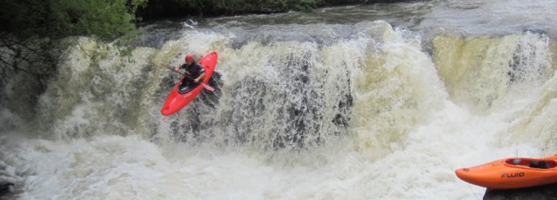
Thrombi-gorge has been a backyard run for a lot of the great SA kayakers.  It is a real classic in the sense that it has pretty much everything you want from a section.  It has a mini gorge that is fairly continues, boulder gardens and ends with a waterfall.

Put-in:  Bridge crossing river (just after UMzimkhulu River lodge).

Take-out (Short): The take-out is on private property.  Arrange with the farmer before you make use of his land.  The farm is down the first road on the left after the bridge (29°53’22.71″S ; 29°34’18.39″E).  At the farmhouse and the gate leading to the barns, turn left (house will be on your left) and pass through the gate.  Continue on and you should get to another gate.  Follow the jeep track to where the road ends (flat area at the top of the hill – 29°53’41.17″S ; 29°35’49.74″E).  Close all the gates and leave the place as you got it.    

If you put-in at the bridge you have a short flattish section to warm-up.  The action starts about 1km.  You will pass a big cabin on your left side and from here you have about 200m before you enter the mini gorge.  This section is normally the section raced during the Thrombi X-fest (held Jan/Feb).  The entry rapid to the gorge is a small horse-shoe drop (1m).  If you don’t know the section, you can get out before the entry drop and walk down the right of the river and scout the first rapid (Slot-machine). The mini-gorge is about 500m in length.  The two major rapids in this section are Slot-machine and Supertube.  Supertube is located at the end where the river makes a sharp turn to the left.  The line is on river right.

After the mini-gorge or race section, the action continues with Boof-auto-matic (line is over a ledge on centre-right), Ski-jump is a sloped ledge (line is on river left – tucked behind a boulder), Golf-course (continues boulder garden with a couple of holes) and Cheese grater (last rapid above the falls).  At a low and medium level it is easy to scout and even boat scout.  When the water gets up, scouting becomes more difficult since the river is continues.  Best to know the river before you jump on at a high level.  The falls also becomes a portage at higher levels.

Thrombi falls is about 8 – 9m high.  It has a hole just above the lip of the waterfall (allows for debate whether the best line is left, right or punching the hole).  You can either get out above the last rapid before the falls to scout (flat rocks on river left) or run cheese grater and then get-out (also left).  The waterfall has a pocket on the right and an undercut on river left.  Safety can be set-up on a ledge half-way down the side of the waterfall river left.

The waterfall is the take-out for short Thrombi.  The easiest way out is to take-out just above Cheese grater on the right.  Hike-out to the top of the hill.  Vehicles (read bakkie or 4×4) can be parked at the top of the hill (some guys manage to miss where the vehicles are parked, so walk up to the top rather than following the gulley).  If you ran the waterfall, portage back-up to the top of the falls on river left.  If you use this take-out, you have to arrange for access from the farmer.

Long Thrombi:  It is best to paddle this section on medium and high flows since the river towards the end flattens out.  There are still one or two biggish rapids after the waterfall.  Everything is run-able and pretty easy to read and run.  There are two take-out options:

1.  At the newly build suspension walk bridge across the river (29°56’58.16″S ; 29°39’50.79″E ).  The access road to the suspension bridge is to follow the take-out road of the Polela and carry-on over the take-out bridge for the Polela onto Qulashe (Check google earth)

2.  At the onlfuence of the Polela and UMzimkhulu rivers. (29°56’53.19″S ; 29°42’20.93″E)


Leave a comment

Howick Gorge / Umgeni / KwaZulu-Natal / South Africa

    Umgeni River – Howick Gorge

Howick Gorge : Umgeni River

Grading  IV- to IV+ (V when high)
Levels / gauges Low: 8 – 14m3/s

Medium:  15 – 20m3/s

High: 21 – 30m3/s

Pumping: +30m3/s

Check if Midmar dam is full (either through Umgeni Water or Department of Water Affairs).  It needs to overflow for the section to work.  *Final check is at the waterfall – if a full curtain is going over the falls, then it is a good medium level.

Put-in 29°29’8.15″S ; 30°14’21.03″E
Take-out 29°27’54.98″S ; 30°17’20.90″E

(Get hold of Ezemvelo KZN for the time being – weekdays 0338451996/7)

Alternative take-out 29°26’32.13″S ; 30°19’47.03″E
Estimated time 2hr to 5hrs
Length 10km
Gradient 22m/km
Portages None (*optional portages)
Hazards / Notes Walk-in / Access at take-out / Logs
Fun factor 4 / 5

The Howick section is fun and continues and can challenge both intermediate and expert kayakers.  The best of all is that everything is pretty much runable, with maybe two scouts required if you are on top of your game.

Put-in: The put-in to this fun section is really easy to find.  Drive into the town of Howick and follow the signs to the look-out over Howick Falls.  The look-out for the falls is on the southern side and there is a small tea garden on opposite side of the look-out (stand with your back to the falls).  You have to hike down with your kayak to the pool below the falls.  (Pay about R25 at the tea garden to get access).  Follow the marked route down to the base of the falls.

Take-out: The take-out is at Hilton College.  If you are driving towards Durban from Howick (easternly direction), take the second Hilton turn-off and turn left towards Hilton College.  You have to organise to gain access to the take-out beforehand.   Follow the road until you get to the guarded access gates.  Be super friendly with everyone you come into contact with since it is a privilege for kayakers to be able to gain access to the take-out.  They will give you directions towards the game reserve.  If it rained a lot, you will need a 4×4 to get down to the river, or else a 5km uphill walk waits at the take-out.  I will update the number once I get hold of it again (Try Ezemvelo KZN 0338451996/7 for now).  Alternative take-out is on the road towards Karkloof Spa (Otto’s Bluff road). 

The first rapid from the put-in is a good indicator of what is to come.  This follows into the first big rapid of the section.  The second rapid consists of a tiered dropped on the left and a drop onto rocks on the right.  The most common line is on the left, so take-out on the left just above the drop to scout.  It is basically a drop onto a sloped rock that drops off into a pool.  When the water lands on the sloping rock, the flow turns 90degrees to the left and drops into the pool.  A good entry boof is advisable.  Take note of the syphon downstream of the plunge pool.  It is located downstream on the left and you need to pass upstream of it into the main flow of the river.

From here the river is fairly continues with easy read-and-run rapids.  If you can’t see your next move, then get out and scout.  About 2.5km into the section you should get to a U-shaped drop, the drop is runable, but make sure you stay away from the left side ledge since this is an undercut.  A alternative line to this, if the water is up, is to sneak past on the left and run the 2m drop on the left channel.

1km down from the U-drop is a double drop.  This is not a technical drop, but it sneaks up onto you and can dish out a solid beating at higher levels.  After the double drop the actions continues with grade III rapids with the odd IV thrown in.  The river also starts to channel a bit more towards the end, so try and follow the main flow where possible.  The take-out is at the Hilton College / Ezemvelo KZN reserve and your well trained seconds should be waiting there with some cold beers.

If you carry on to the bridge close to Karkloof, watch out for low level bridges.  The channels get more and the gradient flattens out.  It is about 3km to the alternative take-out.

Awesome section and if you have a solid and small crew, you can do this section in less than 2hrs.  Always keep an eye open for logs on this section.


Leave a comment

Polela / KwaZulu-Natal / South Africa

Polela River

Polela River
Grading +IV (V)
Levels / gauges Level gauge is out.

Check level as you cross the Polela on your way from Bulwer to Underberg.

Level is hard to pin-point but work on teh following:

Do-able: River is bank to bank and just starting to burst the banks at the bridge.

Pumping: Water is brown and over the banks.

Put-in 29°50’2.64″S ; 29°38’53.87″E
Take-out 29°53’24.48″S ; 29°39’31.28″E
Estimated time 2-4hrs
Length 10.6km
Gradient 22m/km for first 6km. 15m/km.
Portages One
Hazards / Notes Waterfalls
Fun factor 4.0 / 5 (Full it is a 5)

The Polela is likely to work when Thrombi is pumping at about 40cumecs.  Best way to know if it is working, is to drive out and check it.  There use to be an old stormwater pipe that was used to gauge.  If the water is well over the pipe, then it was good to go.  Low water on the Polela means walking and scraping (especially the last couple of km’s to the take-out) so rather hit Thrombi or something else.

The put-in is at the bridge.  For the take-out, drive towards Bulwer and take the D-3 dirt road on your right.  Carry-on with this road for about 9km until you cross-over the Polela.

The Polela is best known for two things: Waterfalls and T-bone/V-bone.  The action starts off with Horseshoe drop.  The normal line is on the right and launching from right to left.  Other lines exist on the left, but be cautious of running the slot.  Hazards such as logs can be hidden from view.  The waterfall is about 2km downstream of the put-in bridge.  A 3-4m drop is the next waterfall.  The line is easy and you can scout from the right bank.  After the second waterfall (about 200m) you will get to the portage.  Portage on the right.

For about 1.5km you will have rapids leading to the next waterfall set.  The landmark is a house on the left bank.  Scout from the left bank (easy to portage as well).  After this you will get to T-bone/V-bone.  The rapid has a steep lead-in which ends in a micro pool above a slot.  Scout your line from the right bank.  There is a big pool below the drop.  This rapid has dished out in the past to kayakers messing up their line and things are unlikely to change.  With higher levels, things don’t get any easier.

From T-bone/V-bone onwards the river looses gradient and you paddle through easy class II/III rapids lined on the side by black wattles.

The Polela is great at a high level for competent paddlers.  It is also possible to do Thrombi in the morning and Polela in the afternoon run.


Leave a comment

Bivaan / KwaZulu-Natal / South Africa

Bivaan Gorge (Below Paris Dam)

Bivaan Gorge
Grading +III
Levels / gauges Dam level @ Bivaan at Paris Dam (Usutu and uMhlathuze)Low – 10 to 20

Medium – 20 to 40

High – 40 to 50

Pumping – 50

Put-in 27°31’15.18″S ; 31° 3’17.74″E
Take-out @ Ithala Game Reserve on Pongola 27°27’57.04″S ; 31°16’37.99″E
Take-out @ confluence 27°26’50.50″S ; 31°12’14.62″E
Estimated time Easy overnighter or 6 – 8hrs one day.
Length 43 km (Can be 10km shorter if you take-out at the confluence)
Gradient 10m/km
Portages None
Hazards / Notes Wildlife / isolated gorge
Fun factor 3.0 / 5

This  section of the Bivaan River forms part of the annual Ithala Challenge.  You can get pretty good info on the river section  on the race website.  The race is usually held in late November and is open for K1’s and K2’s with some guys opting for kayaks.

The put-in is below Paris dam.  It is within a reserve and you need to pay for access.  (The turn-off is on the R69 between Vryheid and Louwsburg).  The take-out is within the Ithala Game Reserve.  Again you need to pay for access. The Ithala Game Reserve is located outside of Louwsburg.  The conventional take-out is the same as for the race, which is actually on the Pongola River.  An alternative take-out is at the confluence of the Bivaan and Pongola Rivers.  Take note that you need a 4×4 to get down to the river via the jeep track (check with park officials for details and condition of jeep track).

The majority of the section is on the Bivaan River.  All rapids are good to go in a kayak.  The nature of the river is within the easy class III type rapids with pools in between.  This  section is good for an easy overnighter  and raft friendly (2-man).  There are mainly three rapids that might need you to up your attention levels and they are located at 12km, 20km and 24km mark.  The rapids are easy to scout from the banks or from your boat (if you know how).

The river level is dam dependant and you need to check the dam level and possibly the outfall level.  You can try and get hold of the dam operators and see if they can give you any feedback.

The section is pretty isolated so make sure that you prepare and pack accordingly.  Hand paddling 40 odd kilometres can suck.  Note that there are some flat-dogs in the Pongola River.  Don’t hang around in pools and get the last 10km on the Pongola behind you.

What the Bivaan lack in difficulty, it makes up for in scenery and is well worth a paddle.


3 Comments

Umtamvuna / Kwazulu-Natal / South Africa

Umtamvuna River – Port Edward

Umtamvuna
Grading -IV (V) (High water IV+)
Levels / gauges *   Gauge is down at the momentUmtamvuna @ Umtamvuna WTW (Mvoti to Umzimkulu

Low – Below 15

Medium – 15 to 25

High – 25 to 35

Pumping – 35

Put-in 30°53’39.80″S ; 30° 7’5.85″E
Take-out 31° 4’1.06″S ; 30°10’51.33″E
Estimated time Overnighter (12 hrs – 14hrs) or long one day.
Length 32 km
Gradient 18m/km
Portages None
Hazards / Notes Ledge holes / isolated gorge
Fun factor 4.0 / 5 (Classic 5 if the water is up)

The Umtamvuna is located on the boundary of Kwazulu and the Eastern Cape.  The section is within an isolated gorge which is spectacular.  The isolation ups the level of the run as well, with proper preparation required to ensure that a walk-out does not become an option.

The put-in is at the pumpstation for the Umtamvuna WTW.  To get there, drive along the Izingolwene Road (when entering Port Edward from Durban, it is the road to the right at the traffic lights).  Have a chat with the guys at the water works.  They can give good info on the water level for future paddles down this section.  The take-out is either at the Old Pont resort or push to the beach.

This section is great because there are no portages (can change if there is wood) and a competent paddler can boat scout almost the entire section.  The action starts as you round the corner from the pumpstation.  The nature of the run is fairly continues with ledge holes and some tight lines.  At higher flows, swims should be avoided due to the continuous nature of this section.

This section has been done in a day, but you need to get on early to allow for enough daylight.  You know you are well over halfway when you pass a large tributary coming in from river right.  Other action in this section includes a ledge drop of about 2-3m.

There are sections that you will have to scout.  A competent paddler class IV (which should lead this section) will spot the hazards and/or horizon lines.  Note that there are higher graded rapids on this section and this is why the (V) in the grading section is there.

This section is fun, but the water levels are fickle.  Best to do this run when you are in the area or if you have confirmed info on the water levels.  The section does not hold water for too long, so you need good rains probably one to two days prior to the mission.


Leave a comment

Tugela Canyon / KwaZulu-Natal / South Africa

Tugela River – Canyon section (Colenso to Weenen)

Tugela River – Canyon section
Grading -IV (V)
Levels / gauges Tugela @ Colenso (uThukela)Low – Below 70

Medium – 70 to 160

High – 160 to 300

Pumping – 300 and up.

Put-in 28°42’3.21″S ; 29°49’38.44″E
Put-in Alternative 28°40’37.32″S ; 29°52’19.42″E
Take-out 28°45’25.23″S ; 30° 9’1.14″E
Estimated time Overnighter (12 hrs – 14hrs)
Length 53 km
Gradient 15m/km (sections where gradient increases significantly, but flats take it up on average)
Portages Yes (2)
Hazards / Notes Holes / Semi-isolated gorge
Fun factor 4.0 / 5 (Classic 5 if the water is up)

The Tugela Canyon section is a classic run and best to it as an overnighter.  Put-in is at the Onderbroek-spruit on the road towards Ezakheni (turn right from the R103).  You will see an railroad bridge over a little stream and the Tugela River in the background.  This is the put-in for the complete section which includes Hartshillfalls and Little Augrabies.  An alternative put-in to skip the portage and the waterfall is to get-in at the pumpstation (see alternative put-in coordinates).   For the alternative put-in you need to drive toward Ezakheni.  When you cross the railroad, immediately after that you will get to an intersection.  Take the road to the right (double back along the road you came in, but on the other side of the tracks) and carry on until you get to the waterworks and then the pumpstation.  You can use this also as a take-out if you want to run the top section and the section below the pumpstation.

For the take-out: What we have done in the past differs.  You can either organise with Zingela (Lodge on the banks of the river) for a shuttle (cost involved).  Alternatively you can leave a car at their house in Weenen (arrange with them first) or at the police station in Weenen.  Carry-on to the take-out at the bridge and then either catch a lift into town with a taxi (road is semi-busy) and get the car for the pick-up.  Don’t bank on the police to help out with logistics.  You are lucky if you bum a lift.  It is always a good idea to get hold of the guys down at Zingela and just let them know that you are paddling down.  (Note – great place for seconds to stay).

Once you are on the river from Onderbroek-spruit:  The first obstacle is Hartshillfalls (10-12m) and is about 1.5km from the put-in.  At low flows you can scout the falls from the edge, alternatively you need to bundu-bash on the left bank.  The line is towards the left of the river.  On the right it forms a messier cascade type falls.  There are however numerous lines and the pool at the bottom is generally deep everywhere.

For 1.5km it is more than drop, but then you will enter some small continuous rapids building up.  Get out on the left bank before you go down too far.  This is the portage, Little Augrabies.  Do not eddy hop until then end, because you run out of eddies very quickly and you do not want to go down this thing.  A swimmer at this point is a problem.  Portage on the left and get in below the falls and run the last couple of meaty holes.

The next landmark is a pumphouse on your left with a weir stretching across the river.  This is Colenso Falls.  It totals in the region of 30m.  The lines on the right is out for now, but on the left there are several smaller drops and slides with multiple lines.  There’s a drop on the bottom right (about 7m) that starts to work at higher flows.  If you are not keen on this, portage on the left (old way was to portage down the centre island, but this can be a mission).  About 500m below the cascades, there is a playhole good to go.

Below Colenso Falls you start to enter the gorge.  Everything from here-on is good to go with the odd scout required.  It is a good idea to push past the Klip River (biggest river coming in from the left) if you are doing an overnighter.  The Klip joins the Tugela 11km downstream of Colenso Falls.

The commercial section starts about 10km upstream from Zingela Camp.  The land mark is pretty difficult to spot, but there is an old farmhouse on the right bank (About 500m from the river bank) and you can also see powerlines on the hill on the right.  The section includes Frog’s playground (big holes and waves at high levels – 200up), Washing Machine (Need to scout this rapid on the right hand bank) and Liquidizer.  After this you will spot Zingela camp on river right.  The section to bridge and take-out is milder and you the gradient drops.

Note – Camp on right bank of river. The gorge is pretty isolated and a hike-out will be a crappy option.  Take the right equipment and group for a trip like this.  This section is also ideal for rafts.