Mac-Mac River – Lower MacMac
|
Mac-Mac River – Lower MacMac |
|
| Grading | III to IV (V) |
| Levels / gauges | Visual: Confluence of Sabie & Mac-Mac (if it runs brown and the Sabie is up, it should be good to go)
Alternative is gauge (DWA hydrology site) Mac-Mac @ Geelhoutboom: 5m3 and up. |
| Put-in | 25° 0’11.40″S ; 30°55’25.26″E |
| Take-out | 25° 1’49.30″S ; 31° 1’33.10″E |
| Estimated time | 3.5 to 5hrs |
| Length | 17km |
| Gradient | 15m/km |
| Portages | Venus Falls portage (possibly two other depending on water levels) |
| Hazards / Notes | Low level bridges / trees |
| Fun factor | 3 / 5 (Nice one if the water is right) |
The Mac-Mac is hard to get at the right water levels. The catchment is right next to the Sabie’s catchment, but doesn’t hold water as well as the Sabie. The lower Mac-Mac is in some ways easier than the Sabie U2 section with longer pools between sets of rapids. The river is easy to paddle with all major obstacles being marked by bridges (be it low level or ones you can paddle under).
The put-in is at the Sappi Forest Service Station. Drive on the R 535 from Hazyview to Graskop. About 25km from Hazyview you will see a turn-off onto a dirt road with a sign saying Sabie to the left. Take this road and drive down (might need 4×4 if rainy) until you cross the Sunlight stream bridges. You can either put-in here or drive further to the Mac-Mac. The Sunlight stream provides a bit of warm-up in the way of low volume creeking.
The take-out is at Induna Adventures (ask permission to take-out on their property).
On the river:
The Sunlight stream has a short steep section before it joins the Mac-Mac. Once you are on the Mac-Mac the volume should pick-up a bit. The rapids that follow are easy to boat scout and all are runable. The river banks are mostly flanked with indigenous forest with pine plantations on the valley sides.

(Typical Rapid Mac-Mac)
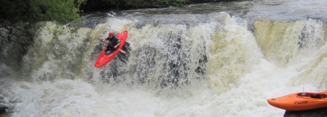
The first major obstacle and still a portage at the moment (needs some time to work on a line) is Venus Falls. The falls are 2.5km from the put-in and marked by a low level bridge. If you see a steep increase in gradient and a horizon line, eddy out on the right. Take a look at the slide / falls. The best place to portage is on the right side, so follow the road down to the picnic site.

(Venus Falls)
After Venus Falls the river carries on with the same characteristics as above the falls. All rapids are good to go and there are only two sets of rapids that require some scouting. The first is marked by a bridge you can paddle underneath. There is a nice undercut on the right side and this rapid leads into a slide. This bridge marks a set of cascades and slides. There are lines down most of the slides/drops, but can get a bit tricky if the water is up. Scout on the right side. Depending on water level, the portage might be easier on the left hand side (high water).

(Cascade Section)
The last set of rapids contains a huge syphon at the end. The set is marked by a bridge (you can paddle underneath it). Best is to get out early and scout the rapid. The last drop contains a syphon (read big syphon). The river cuts to the right over a drop with the syphon being in the lead-in to the drop. It is easy to portage on the right.
Once the syphon rapid is done, cruise down to the take-out.
Just a word of caution: There might be crocs on this section, so keep a look-out. There is definitely crocs closer to the take-out so just ask the guys at Induna Adventures if it is something to be concerned about
The Lower Mac-Mac section is a good option if the Sabie is too high and if the group needs a bit of confidence.
