As / Ash River
|
As / Ash River – Clarens |
|
| Grading | III+ mostly (Bridge / Slide / Waterfall is IV) |
| Levels / gauges | Ash @ outlet from Katse Dam (Upper Vaal)
Flow is fairly constant with the following guides: 10 – 20m3 is considered lower flows. 20 – 30m3 is normal flows. 30 – 40m3 is high (normally in the winter) The lines don’t really change for the different water levels. |
| Put-in | 28°26’22.09″S ; 28°23’51.18″E |
| Put-in at Bridge Rapid | 28°24’54.82″S ; 28°22’30.64″E |
| Take-out | 28°19’43.27″S ; 28°22’36.14″E |
| Estimated time | 4-6hrs |
| Length | 17km |
| Gradient | 5m/km (rapids with large pools) |
| Portages | 3 |
| Hazards / Notes | Weirs / tree / slalom gates / collapsing banks |
| Fun factor | 3 / 5 |
The Ash / As River (we’ll stick with Ash) is part of the Lesotho Highlands Water Transfer Scheme to supply the mining rich rand area with water. This means that there is generally a steady flow of water in the river. Winter time tends to have higher flows since they use the tunnel to produce hydro electricity. The river is pretty much runnable whole year long (except if they are doing maintenance on the infrastructure and tunnel). This feature makes the Ash a nice fall back to have for paddlers based in the Johannesburg and even KwaZulu-Natal midlands area. The Ash is probably known best for three things: Cold water (by SA standards), timely beatings on Fish Pond and parties in Clarens.
The description is based on the put-in from the outfall tunnel. Get-in by shouldering your boat and taking a walk along the right of the river from the parking lot to the pool below the first set of weirs. The first paddle will be over Boston Dam to the next weir. This is the stepped weir and you can either portage on the left or right side. The weir has been run from top to bottom. The first weir is shallow at the bottom so don’t try it. The next one can be run by launching into the turbulent pool between the two and the running down the steps. It isn’t really common to run this and easier to just portage it all and get in at the pool below.
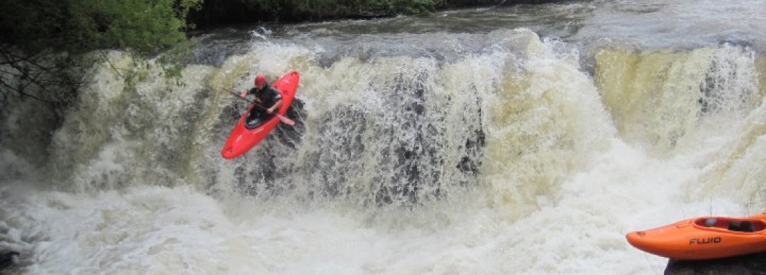
The first real rapid starts about 200m downstream of the stepped weir. Everything is runnable, but lookout for fallen trees. The banks are constantly changing and this can cause trees to fall across the river. Normally everything is pretty open since commercial rafting takes place here and you can see a hazard from far away. Allesverloren can be identified by slalom gates. It is one of the longer rapids on the section and starts out with a wave entrance (surf-able, but shallow). The next rapid is Fish Pond or Bridge-rapid (marked by the bridge passing over the river at the entrance of the rapid). Scout the rapid from the left bank. This rapid has given many a gumby nightmares.
From Fish Pond you will get to a weir that stretches over the whole river. Do not run this and get out on the right or left to portage. After the weir there are a couple of smaller rapids until you get to broken weir. This was low water crossing, but has turned into a shallow sloping rapid which you want to stay upright for. Following the broken weir you will get to Big Surprise (400m from broken weir). There are lines on river left and right with the more common line on the left.
The next portage is the start of the hydro plant. You have two options here. See how much water is being diverted from the river to the hydro system. Basically if the horse weir on the left is running over proper, then you have the option to portage on the left. If it is bone dry over the weir, take out on the right and put-in after the hydro channel flows into the river again. Watch-out for the hydro intake and keep clear of it all of the time (man-made syphon). If the not much water was being diverted, then carry your boot on river left past the next rapid (boulder choked rapid) and get in at the pool. (Hydro plant will be on your right). Paddle the set of rapids that leads into a flat section. The flat section is about 200m long and forms an S-bend. This leads into a 2m drop. Scout the drop from the left bank. Take note that there is a nasty undercut on river left and that a lot of water pushes into this. If you decide to run it, make sure to set up safety and boof it. The line centre and/or centre left. The rapid below has a shallow hole. Guys that portaged on the right above the hydro plant will join the river below this drop and rapid.
There are no more portages from here. The only other note worthy rapid is the slide. It consists of a sloped weir that leads into a long rapid filled with some nice holes. The rapid can dish out, but likely there is a large pool at the bottom. Carry on to the take-out where the main road crosses the river (take-out river right).
The Ash has long flat pools which is made a bit better with the constant flow and the rapids between pools. The Ash has become a favourite in the dry winter months. The river is also a great introduction river for intermediate paddler wanting to work on their river running skills. Don’t miss out on the annual Ash-festival taking place in July every year.
Side note: The Ash River is under threat of damming. Be active and post pictures / reports of people using the river for recreational paddling. This will enable the paddling and rafting community to give better opposition and/or influence decision when it comes to the river.
